All Posts in Noticias

November 19, 2024 - Comments Off on We have obtained the Innovative SME Seal

We have obtained the Innovative SME Seal

We are pleased and proud to announce that we have just obtained the INNOVATIVE SME SEAL. You surely know that innovation is one of the fundamental pillars on which Nova Cartografia is built. We firmly believe in continuous improvement and investment in Research, Development and Innovation (R+D+i). We are constantly developing new technical and management tools that help us to improve the efficiency of processes in order to add value to the services we offer.

Sello Pyme Innovadora

This is a distinction granted by the Ministerio de Ciencia, Innovación y Universidades. One of the most valuable assets for a small and medium-sized company that is linked to research, development and innovation activities.

Renderizado BIM de la estación Valencia Joaquín Sorolla

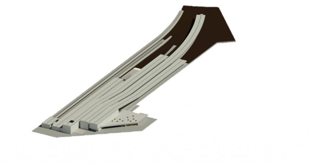
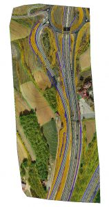
BIM rendering of the Valencia Joaquín Sorolla station

¿And what does it mean to have an Innovative SME seal?

It means that, in recent years, at Nova Cartografia we have carried out activities in the field of Research, Technological Development or Technological Innovation (R+D+i) and therefore, the Ministry of Economy and Competitiveness recognizes us as an accredited innovative company.

We are committed to the technological avant-garde and seek innovative solutions for each of the projects we undertake.

But innovation is not only a business objective, it is also a way to contribute to the progress of our sector. By obtaining this recognition, we reaffirm our commitment to excellence and to the search for new solutions that benefit society as a whole.

This achievement is a source of pride for the entire Nova Cartografía team. It is the result of a joint effort of all the professionals who are part of it and a sign of our passion for cartography.

Estructura de la estación Valencia Joaquín Sorolla

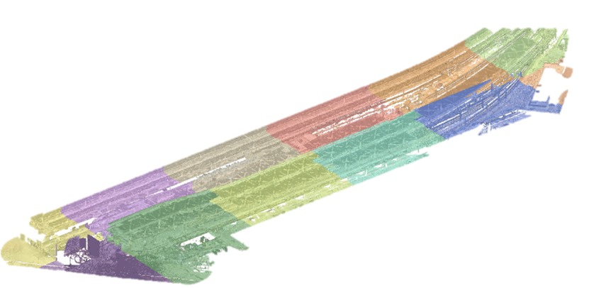
Structure of the Valencia Joaquín Sorolla station

Do you want to know more about how our team of professionals can benefit your project?

Get in touch with us and find out how we can help you achieve your goals.

July 21, 2022 - No Comments!

Technical assistance on site

At Nova Cartografía we start by carrying out isolated stakeout work and analyse the project in its geometric aspect. We also fit it into the ground and we monitor the execution of the work in terms of stakeouts and measurements.

We carry out the initial detailed topographic survey with the latest technology in GPS receivers and total laser scanner and drone stations. We will make sure that data collection meets the needs of our clients, with all the necessary data for a correct study of the needs of the work.

On-site technical assistance also encompasses all those interventions carried out during each phase of the project that are aimed at ensuring that everything is being done correctly, safely and taking into account the different geotechnical fields that affect the works to be carried out, solving all the unforeseen events that may occur. Technical assistance helps to intervene by minimizing errors and reducing costs in the final resolution of the project.

Checking the stakeout bases, both the precisions and their distribution, the work methodologies, the reference system used, performing precision tachymetric, geometric levelling, all kinds of checks, cubing for monthly certifications and auscultation in all types of works. The topographic bases of the project work are prepared taking into account the times and control of measurements, offering peace of mind in the minimization of errors.

The main services we offer at Nova Cartografia are mobile mapping, track trolley, track auscultation, laser scanner, drone mapping, and BIM, among others. Our services intervene in the construction process in all its stages: from construction to maintenance once the work has been completed.

Our experience covers linear works, structures, railway works, dams and channeling, urbanizations, deformation control, etc.

July 18, 2022 - No Comments!

Laser scanner: versatility in data collection

Laser scanner technology offers high accuracy in measuring objects or surfaces located within a limited radius. It offers the opportunity to be able to transfer any object or terrain to a plan or model, with high precision. Laser scanner devices work by using laser waves that calculate the varying lengths of nearby objects, which can be observed on the scanned surface.

Initially, it is based on a detailed study of the type of work and its needs, the characteristics and dimensions are two fundamental factors to be able to prepare and calculate the field work properly.

Planning in the use of laser scanners is essential to improve productivity and work efficiency. At Nova Cartografía we have different types of laser scanners, and we evaluate which one is optimal for each project.

  • Optimal equipment and instruments
  • No. of scans and position
  • Time Spent Estimation
  • Georeferencing coordinates

When collecting data, we select the resolution according to the ambient light intensity and the desired quality. We position targets,  support targets that will serve as a reference to unify the different scans with higher precision. The laser scanner measures millions of points with high precision and in a short period of time. Sometimes you will need to make different captures from different stations or positions to ensure complete coverage.

The methodology followed by the use of laser scanners serves to collect information in the area of intervention, allowing important information to be seen between the points.

To talk about laser technology is to talk about millimetric precision. This quality guarantees its corresponding calibration:

-Point cloud in open format: they will provide the necessary information to later process the data.

-Delineation required at each step: with great precision it will allow the client in future consultations to access to be able to make new modifications in the project/work.

The objectives to be developed in a laser scanner job are based on anticipating conflicts, being an easy way to save on execution costs. The intervention has to be analysed using real models of alternatives, ensuring a survey of plans with high millimetric precision. The distinction in a high-precision technological service gives confidence to your customers and ensures greater efficiency in the service. The potential of the object allows the real object to be transformed into a virtual one and to be able to make certain changes to it by manipulating it until the desired result is obtained.

In the laser scanner there are two types of sensors, short and long range, depending on the size of the type of object; it is the scanner itself that calculates the distance from the object using its laser light beam.

The performance of the station helps to obtain measurements with the required accuracy, evaluating workflows and not just the speed of points per second.  Reconnaissance of the intervention area to collect information is essential to be able to organize the necessary sweeps of the surface to be analyzed.

July 15, 2022 - No Comments!

Track assembly with track trolley

At Nova Cartografía we start from a study of the parameters of the track on which we start, certifying the necessary lifting and ripping of the track. The track trolley helps to avoid having to pass through the same point with the total station, since with the trolley we manage to obtain all the necessary parameters: level, width/cant and arrow handles. We continue with the control and analysis of the existing network, taking a reference system.

Then we go on to implement the network, obtaining the topographic and altimetry network, executing the works and subsequently monitoring  them.

The speed of the track carriage demonstrates a great ease to export graphs and tables of observed data, giving the tamping machine real-time data on the track condition and also export the data to provide it without edits. All this together with a smaller mesh pitch without having to reduce productivity. Various  phases are included in track assembly:

  • Ballast spreading        


  • Sleepers placement on track

  • Rail distribution and track assembly

  • Leveling and stabilization

  • Railroad Qualification

July 13, 2022 - No Comments!

Precision photogrammetry: value to information

It is one of the techniques with the greatest precision and with which we manage to provide value to information. The photogrammetry technique can be performed both on the ground and in the air. In the latter case, we have a minimum cost budget, since little infrastructure is required to take photographs.


During drone photogrammetry:

  • Capturing aerial photographs
  • Processing using specific programs to obtain 3D models and orthomosaics, obtaining accuracies of around 1 cm in planimetry
  • We obtain digital cartography and orthophotos of maximum precision, especially in areas of difficult access, avoiding endangering field personnel

Among the most outstanding standards, we highlight the ease of obtaining a large amount of graphic information of the area where the survey has taken place, the efficiency when representing the surface with points and the final cartography obtained. By using this technique, we obtain quantifiable information from the terrain and physical objects, reconstructing the environment digitally through georeferencing and high-resolution aerial photographs, using the superimposition of photos to generate 2D and 3D products. Using drones to map large areas, compared to terrestrial surveying, results up to 80% faster in surveying operations.

Photogrammetry helps to obtain high-resolution orthomosaics and 3D models with a very high level of detail in areas where detailed information is not available. They are executed quickly with precision and accuracy, providing much more detailed information.

Work site monitoring is also carried out to certify earth movement, obtaining the digital model of the terrain of inaccessible areas and even  360º photos.